Sunday, Sep 27, 2020 12:00 [IST]
Last Update: Sunday, Sep 27, 2020 06:25 [IST]
Galathea River
S. BALAKRISHNAN Galathea River is not as famous as it ought to be, despite being
India’s Southernmost River. So, on World Rivers Day let us visit Galathea flowing quietly and perennially far down south in Great Nicobar Island, the southernmost land territory of India.
Well, the name Galathea might sound a bit quizzical like a Hindi name. My guides also confirmed this during my expedition to India’s southernmost point Parsons Pygmalion Point (now called Indira Point) in 1979. They explained it quite simply - ‘Galath’ in Hindi means ‘wrong’; because this river was unpredictably in spate quite often proving ‘wrong’ the calculations about her flow and force, hence the name ‘Galathea’! Fantastic story, I chuckled to myself when I later read the truth.During 1845-47AD, the Danish vessel ‘Galathea’, circumnavigating the world, spent some months in the Nicobar Islands, surveying for coal and other minerals. The team led by Captain Steen Bille could have named this river as Galathea.But much earlier to this, i.e., in around 1000 A.D. itself, the Chola Kings of Thanjavur in Tamil Nadu called this river as ‘Kaalathi’ and the Nicobar Islands as ‘Nakkavaram’.
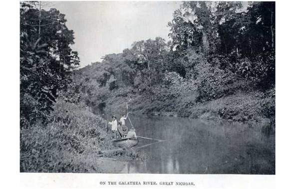
I had imagined Galathea to be a shallow creek with ankle-deep flow. In fact, her credits are many. Perennial rivers are almost nil in the Andaman & Nicobar Group of Islands, Great Nicobar Island being the only exception. It has not one but five perennial rivers. Galathea is principal among them and also the longest - 40 km. At source, which is hardly approachable due to thickest vegetation, she is about 25 ft. wide and near the mouth, where she meets Indian Ocean, she is about 90’ wide with an awesome flow. She has a navigable 30 km. upwards from the mouth. The Galathea basin is 41 km down the North-South Trunk-road from the port town of Campbell Bay, headquarters of Great Nicobar Island. With tributaries adding to her flow, Galathea flows down south from Mt. Thullier range, the highest point in Nicobar Group of Islands. Her depth ranges from 15 to 20 ft. on an average. The banks are covered with abundant growth of wild bushes, towering trees, swinging creepers and grass lands, so much so that a 1901 expedition to reach her source could traverse only up to 25.75 kmfrom the river mouth due to thick growth. This is narrated in the book “In the Andamans and Nicobars - The Narrative of a Cruise in the Schooner Terrapin", authored by C. Boden Kloss - 1901.
In 1979, though she wore a deceptive look of a calm and smooth-flowing river, transparent like a sheet of glass, I realized her force as we waded across during low tide, after waiting for 4 ½ hours.On our return journey from the Southernmost Point, we found River Galathea flowing in her full might. Maybe it had rained in the catchment areas, my guides guessed. After waiting till noon for the low tide to set in, we crossed her on a dinghy (small country boat) which whirled once violently in the midstream. My guides managed the situation tactfully and we landed safely on the other bank in one piece, without falling prey to the hungry crocodiles or to the mighty ocean. We then proceeded towards Shastri Nagar from where we had started the previous morning.
With recent plans mooted for developing Gt. Nicobar, in an effort to compete with China, I wonder what would be the fate of thisSouthernmost Islandand this Southernmost River Galathea, because development always pulls down Nature. In 1992, Government of India formed the Galathea National Park which is now part of the vast Great Nicobar Biosphere Reserve created in 2013.
Though Galathea twice tried to swallow me, I still wish her a long and unpolluted life, safe from the so-called development plans. By the by, why don’t we follow Modi’s ‘Vocal for Local’ motto here also? I am sure the Shompen tribal who mainly live alongside rivers and only in Great Nicobar, must have a name in their Shompen language for this river; why not rename Galathea by what the Shompens lovingly call it? Long Live Galathea!
[World Rivers Day is a celebration of the world’s waterways, on the 4th Sunday of September. It highlights the many values of our rivers, strives to increase public awareness, and encourages the improved stewardship of all rivers around the world. Rivers in virtually every country face an array of threats, and only through our active involvement can we ensure their health in the years ahead. In 2005, the United Nations launched the Water for Life Decade to help create a greater awareness of the need to better care for our water resources. Following this, the establishment of World Rivers Day was in response to a proposal initiated by internationally renowned river advocate, Mark Angelo. There is also this ‘International Day of Action for Rivers’ that is celebrated on 14thMarch to raise awareness about the importance of rivers and climate change.]
krishnanbala2004@yahoo.co.in / 9840917608 Whatsapp


