Sunday, Oct 03, 2021 09:00 [IST]
Last Update: Sunday, Oct 03, 2021 03:31 [IST]


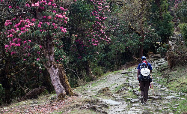
Many of our Gangtokians and from elsewhere have recognized the high forest zone that ranges from Kyongsala, Khedi Menla to Doklam stretch in Rhenock Rongli side in East Sikkim. The Assam and Pakyong reserved forest touching Kyongsala range in East Sikkim has been our holy reserve for centuries. Ramnawami festival in April every year marks the significance of this forest as people from different location gathers and moves towards the high forest trekking across Khedi Menla, near Tsomgo Kyongsala range in Gangtok. Being a permanent resident of Assam Gaucharan, Assam Lingzey, East Sikkim, and having trekked this forest areas many times in the past, I have been witnessing tremendous growth in the number of trekkers visiting this forest areas every year. Rapid urbanization demands secluded environment and green forest at times for a temporary respite from the sounding hiccups that has almost become a routine features in our city life today.
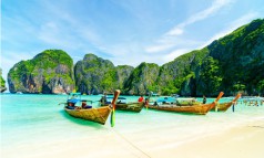
The end destination for any visitors is reaching Khedi Menla which is close to Tsomgo Lake in East Sikkim from various pathways known from ages. Assam Lingzey, Gaucharan Pasatenga and Parakha Rolep Rongli provide a takeoff points for the visitors foraying into the high forest trekking.
High forest is usually known to have been originated from its seeds that occur naturally where we can see large, tall mature trees with a closed canopy.
Across this high forest zone, we have multiple tourist destinations to walk upon. Dhungel Kharka, Tal kharka, Dudiley tar and Ramitey are the few spots that are yet to be registered in the tourism map of Sikkim. Ramitey has a cliff on the hill top which is popularly known as Gorujurey meaning bull’s hump where we can climb the bull’s humped hilltop to view Kalimpong and parts of Darjeeling in West Bengal besides many other unknown scenes on the other side. Between Gorujurey and Khedi Menla, we have two lakes (Locally described as male and female lakes) located little away from each other. Those seeing the swimming white colored ducks in the lakes are believed they will be blessed by the lakes there.
From Pasatenga Gaucharan, we can directly reach Khedi through the beautiful pasture land called Chawri Kharka. If you could taste the butter-made nuts in super market of Gangtok, they are either brought from Dzongri or the Chawri Kharka from East because these are the only few places where the yaks are kept sheltered, nurtured and taken care of.
This high forest near Gorujurey belt has been known for Red panda breeding ground in Sikkim. We have tiger corridor also in the high forest areas of Khedi Menla stretch. Towards the Khedi Chawri kharka site, we have river Taksangchu which originates from there which culminates largely in the Madhya Bharat Hydro Project, Nimtar, Ranipool to generate power besides feeding many villages with its pristine fresh water. This river seemingly very fresh and clean comes down naturally dividing our Syari and Namcheybong constituencies in East Sikkim. There are many rivers I know locally up to Pakyong Rongli side which emanates from these high forest areas such as Bala khola, Tharo Khola and Seleley khola, to name the least which gives fresh life to all of us unhindered and indeed, without paying anything for it in return.
I never knew and I have never thought of in my slightest of imagination, not at-least in my lifetime that these high forest stretches will be soon met with devastation, in the cause of development, for national security and above all to defeat the expansionism policy propagated by the other side of the boarder. Doklam situation was an indication and that indeed has forced this sounding strategy for the nation to build an infrastructure befitting to meet any eventualities.
It is indeed, yes. There is a National high-way road being built by the National Highway Corporation of India Limited (NHIDCL) under the Ministry of Roads, Transport and Highways, Government of India, New Delhi. The construction starts from Rongli, Rolep, Barapathing and then going across to high forest areas of Gorujurey, reaching Khedi Menla and joining the National Highway road at Kyongsala side near Tsomgo Lake.
I have a colleague from the Forest Department who is more of a forest lover than being a forest officer who was expressing equal concern for the impending devastation that is going to take place.
I am devastated more. I have seen these forests, lived below these forests reserve and grown with time, not acting as though I am an environmentalist per se. I may have moved away from this place temporarily but my originality never takes me away.
The story goes on. The road is proposed to takeoff across the ridge forest belt which ideally is to make lesser destruction. But is the destruction avoidable? The pastures of land where there are beautiful tars (flat pastures) are being used for dumping of mud and soil. Chawri kharka which is a home for our indigenous yaks has been mapped for dumping of mud and soil. All those flat pastures found in the midst of deep forest such as Dhungel Kharka, Dudiley etc. which are once the paradise of nature for nature lovers are now being converted into a dumping yard. Dumping of mud and soil does not take place by air; it obviously entails use of more forest lands to transport the mud to the dumping side. We can therefore, imagine the amount of devastation taking place. There are hundred to thousand years old pine trees, Okhar and kattus, some of them measures about 21 inches in size as I am told which are going to fell for the road construction. We can imagine the number of Rhododendron trees, Chimal and the high altitude flowering trees being uprooted and taken away. The number of trees counted for felling is unimaginable.
Does it not affect the source of many rivers which are flowing down to our villages from this high forest reserve? These are rivers which do not dry out during winter. I have a serious concern, my own concern which is that we have an abundant source of drinking water from this high forest source till now. If these rivers get dried out, we may have to grapple with the lack of water for our survival. Our future generation will definitely question the wisdom and the efficacy on our part and the Forest Department in particular is not sensing and sensitizing the impact this project is going to thirst upon us.
We have National highway road, NH-10 from Siliguri Gangtok and connecting Rongli Phadamchen areas from West Bengal side which already forms the corridor for security purpose. This could have been upgraded to meet the growing security challenges of our time, instead of creating a new road from the middle of our forest reserve which has only connectivity objectives for now.
Security is a global concern worldwide; strategy is the only way forward. We may have tourism in its new avatar after the highway is built up there along the way, besides the defense infrastructure being created. We may have a beautiful high altitude road in future, with forest cover on both sides but at such a huge colossal loss on our environment before we attain this imagination. The smuggling and black marketing of the matured forest trees and medicinal herbs will be a new challenge as it creates pathways for such activities, adding woes to the Forest Department, Government of Sikkim. The project has long been sanctioned by the Ministry and hence, there is no going back with its re-thinking strategy with the Ministry now.
We can but hope that there was an adequate discussion and briefings done for the State Government to give a go-ahead in the project, with an alternative plan for the restoration of our loosing century - old reserve.
We can hope that the purpose for which this project has been planned spending about over hundred crores by the Ministry, GOI will serve its purpose. A developmental activity at the cost of environmental destruction has always been an issue but security at the end of the day becomes paramount if it is so. Preservation of our motherland, our natural resources at stake should occupy equal thirst on our priority. Hope all that goes well ends up well.