


Wednesday, Jul 30, 2025 23:15 [IST]
Last Update: Tuesday, Jul 29, 2025 17:34 [IST]


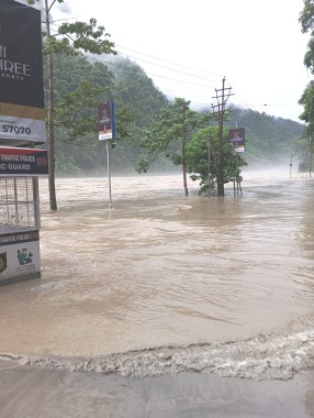
DARJEELING,: NH-10, the crucial highway linking Sikkim and Kalimpong to the plains,
was closed on Tuesday morning after the Teesta River overflowed onto the
roadway. A similar situation was reported on the route connecting these areas
to Darjeeling.
The
water level of the Teesta began receding around 12 noon, allowing authorities
to reopen the highway. However, a massive traffic jam followed, with several
vehicles stuck for hours since morning.
According
to locals, the Teesta River had started swelling from last night due to heavy
rainfall in North Sikkim. In response, police issued precautionary warnings in
areas such as Melli, Teesta Bazar, and Rangpo, advising residents in riverside
villages to remain alert and take safety measures.
By
early morning, the river had already breached the roadside in areas like Rabi
Jhora, 29th Mile on NH-10, and near the Teesta Bridge at Teesta Bazar, cutting
off access between Kalimpong, Sikkim, and Darjeeling. Both stretches remained
closed until water levels subsided and silt and debris brought in by the river
were cleared from the road.
In a
separate incident, a landslide was reported around 9:30 a.m. at Tarkhola,
between Chitrey and Rangpo. Debris and boulders falling from the hillside
blocked the road. The National Highways & Infrastructure Development
Corporation Ltd. (NHIDCL) has been working to clear the blockage and is
expected to reopen the road by this evening.
In
Darjeeling, landslides were also reported on roads connecting Lodhama 1 GP to
Lodhama 2 GP, and on the road from Lingsebung to Mummung Khola in the
Rimbick–Lodhama constituency. These routes have been closed due to falling
debris and boulders.
