


Wednesday, Sep 02, 2026 10:15 [IST]
Last Update: Tuesday, Sep 01, 2026 17:06 [IST]


State proposes solar-powered pumping system to lower lake level; DPR forwarded to NDMA for consideration
GANGTOK, : After more than two and a half years of detailed studies and
painstaking field visits, the Sikkim government has identified three glacial
lakes in North Sikkim as posing the highest risk of a Glacial Lake Outburst
Flood (GLOF), with Shako Chho identified as the most vulnerable.
The
State government has accordingly proposed mitigation measures to the Government
of India, including a solar-powered pumping system to lower the water level of
Shako Chho, a medium-sized glacial lake which is located above Thangu and contains
around 27 million cubic metres of water.
The
proposed pumping system by Department of Science & Technology (DST) aims to
lower the lake’s existing water level further by around 20 metres over a period
of two to three years. The objective is to reduce the volume of water in the
lake and thereby lower the potential impact of an avalanche or other natural
event that could trigger a GLOF.
A
Detailed Project Report (DPR) for using solar-powered pumps to lower the water
level of Shako Chho has been submitted to the Sikkim State Disaster Management Authority
(SSDMA), which has forwarded it to the National Disaster Management Authority
(NDMA). The proposal is currently under consideration, it was informed.
The
urgency for detailed studies and mitigation measures comes in the backdrop of
the October 2023 GLOF-induced flash floods that caused widespread destruction
downstream in the northern and eastern riverine belts of Sikkim and further
downstream in North Bengal along the Teesta River. The recent GLOF which has
devastated Nepal on August 26 has also heightened concerns among people in
Sikkim.
However,
DST officials here said that the level of threat from the identified lakes in
Sikkim is not comparable to the recent disaster in Nepal based on the studies
conducted so far, while cautioning that preparedness is essential given the
State’s highly seismic nature and difficult Himalayan terrain.
National
Disaster Management Authority (NDMA) has identified 189 high-vulnerability
glacial lakes in the Indian Himalayas, including 40 high-hazard glacial lakes
in Sikkim. This means one out of every four high-risk glacial lakes identified
in India is located in Sikkim. Of these 40 glacial lakes in the State, 16 have
been categorised under the highest-risk classification.
Since
August 2024, the State Department of Science & Technology (DST), along with
concerned State departments and Central agencies, has visited and studied 13 of
these 16 highly vulnerable glacial lakes, mostly in North Sikkim.
All
these sites are located above 17,000 feet and are extremely difficult to
access, requiring preparations similar to those for a mountaineering
expedition.
The
most recent multi-disciplinary study expedition, involving scientists,
engineers and geologists, was conducted from July 23 to August 8 this year.
During the expedition, Automatic Weather Stations (AWS) were installed at
Kerang near Gurudongmar Lake and at Dolma Sampa, located below the Lhonak
Valley.
On
Tuesday, DST Minister Pintso Namgyal Lepcha, Principal Secretary Dr Sandeep
Tambe, Secretary-cum-Principal Director Dhiren Shrestha and senior engineers
briefed the media in Gangtok on the extensive glacial studies carried out by
the State, their findings and the mitigation measures proposed to the concerned
Central agencies.
Minister
Lepcha said the DST and concerned State departments, along with Central
agencies such as the NDMA and Central Water Commission (CWC), have been
consistently studying high-risk glacial lakes, mapping their potential threats
and examining the best possible mitigation measures under the direction of
Chief Minister Prem Singh Tamang-Golay.
“People
of Sikkim are concerned due to the recent natural disasters in the neighbouring
country but in Sikkim’s context, such level of threat is not there as per the
studies till now. But anything can happen in future and that’s why we conducted
these extensive studies and are preparing precautionary measures,” the minister
said.
The
DST Principal Secretary explained that one of the main objectives of the
glacial lake studies is to determine the volume of water contained in the
lakes, as the volume of water is a major factor in determining the potential
impact of a GLOF.
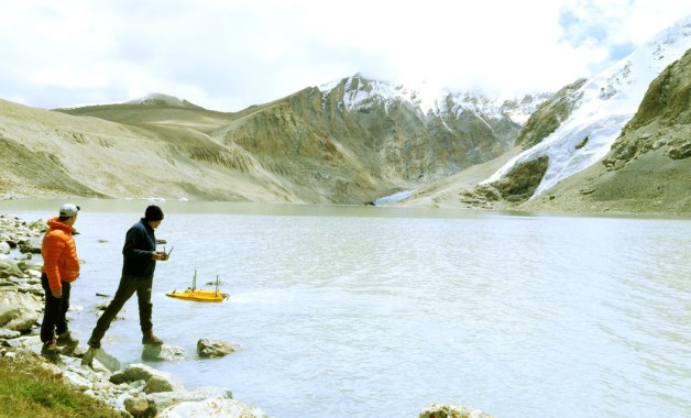
A
specialised unmanned boat is deployed on the lake and remotely controlled to
measure and quantify the volume of water at different points within a glacial
lake.
The
second major aspect of the study focuses on the strength and stability of the
natural dam that holds back the lake, including whether it can withstand an
avalanche entering the lake.
Sub-surface
geological studies are carried out using specialised equipment to assess the
stability of the natural dam and determine the strength of the terminal
moraine. Scientists and engineers examine whether the moraine is composed of
hard rock or softer material and whether water is permeating through the
structure.
The
lateral moraine is also studied to assess the potential threat posed by an
avalanche striking the lake.
“Glacial
hazard is a new threat to humanity because of climate change. Whatever we are
doing, it is for the first time and that is why it takes more time. It is
innovative work which has to be done in very difficult terrain. We have covered
and studied 13 lakes out of 16 lakes and now we have detailed information to
prepare and propose mitigation measures,” said Dr Tambe.
Officials
said the biggest threat that can lead to flash floods from glacial lakes is the
volume of water contained within them. Containing or reducing the volume of
water in the lakes through appropriate measures therefore appears to be the
most feasible approach to mitigating the potential impact.
Three
glacial lake clusters in North Sikkim have been identified as posing the most
potent threat - Shako Chho, the North and South Lhonak lakes, and the
Gurudongmar Lake cluster.
Among
these, Shako Chho has been identified as the highest-risk lake because it does
not have a natural outlet, according to DST officials.
Water
is currently seeping out through its terminal moraine, which officials said
could potentially become unstable. The lake drains directly towards Thangu village,
where several Defence establishments are also located, making it a potential
risk to both civilians and Defence personnel.
Officials
described both the lake and its terminal moraine as fragile.
“Extensive
studies have been done at this lake and all have concluded that it is very
risky. Experts have told us not to touch the lake at all and not to do any
engineering measures. They have recommended non-invasive projects for pumping
out the water from the lake,” said Dr Tambe.
According
to DST officials, a solar-powered pumping system has been identified as the
most viable mitigation option for Shako Chho to gradually lower its water
level.
Once
the water level is reduced, the potential threat is also expected to decrease.
However, officials are still examining what type of pumps can operate
effectively at an altitude of around 17,000 feet.
There
is no electricity supply at the site, while water freezes during winter.
Officials also have to determine how the pumping system can be installed and
operated without creating additional risks to the fragile lake and its
surrounding ecosystem.
The
use of solar energy has been considered because of the significant logistical
constraints at the site. The nearest power grid is around 20 km away, while
transporting fuel for conventional mechanical pumps would require head-loading
over steep and difficult terrain, making conventional pumping systems
economically and operationally unfeasible.
A
solar-powered pumping system has therefore been identified as the most viable option.
Shako
Chho is a medium-sized lake with an estimated total water volume of around 27
million cubic metres.
We
want to reduce the water level further by 20 metres over two to three years so
that when an avalanche comes, the waves and flood are contained within the
lake, said the DST officials.
Officials
explained that once water bursts out of a glacial lake, it gains momentum and
can acquire enormous force as it moves downstream, carrying boulders and debris
along with it. This can significantly increase the destructive potential of a
GLOF. Hence, best preventive efforts should be made to contain the outburst of
water within the lake itself.
Asked
whether a GLOF can be completely prevented, DST officials said Sikkim’s
location in the young fold mountains of the Himalayas and its status as a
highly seismically active zone make it impossible to rule out sudden natural
events.
Earthquakes,
they noted, cannot currently be forecast, making preparedness and risk
reduction particularly important.Preparedness is most important and we have
been taking mitigation measures besides sensitising the people on what steps to
take when a GLOF-like event happens, the officials said.
Following
the Sikkim GLOF of October 2023, the State government constituted the Sikkim
Commission on Glacier Hazard, whose report is currently at the final stage.
Sikkim
has 84 glaciers, each covering an area of more than one square kilometre,
underlining the need for continued monitoring, scientific studies and
preparedness measures to reduce the risks associated with glacial hazards.
The State has also been strengthening its monitoring and early-warning capabilities by installing monitoring and automatic weather systems at Kerang near Gurudongmar Lake, Shako Chu, and Lhonak Lakes.
BOX
Glacial
Lakes in Sikkim: Key Facts
189
-
High-vulnerability glacial lakes identified across the Indian Himalayas
40
-
High-hazard glacial lakes in Sikkim
16
- Sikkim
lakes classified under the highest-risk category
13
- High-risk
lakes studied by the State and Central agencies so far
3
- Glacial
lake systems identified as posing the most potent threat in North Sikkim
84
- Glaciers
in Sikkim covering more than one sq km each
17,000+
ft -
Approximate altitude of the high-risk lake sites studied
Why
Shako Chho is a Concern
Location:
North Sikkim
Water
volume: Around 27 million cubic metres
Altitude:
Around 17,000 ft
Key
concern: No natural outlet
Natural
dam: Terminal moraine considered fragile
Downstream
area: Thangu village
Potentially
exposed: Civilian population and Defence establishments
Proposed
measure: Solar-powered pumping system
Target:
Lower water level by around 20 metres
Timeline:
2-3 years
Status:
DPR forwarded to NDMA; proposal under consideration
